projects
Deep-Blue Visions in the Drafting of Japan’s Pacific Geographies
To be presented at the conference Histories and Society in the Hydrosphere, Duke University, Apr. 28–30, 2023.
Japan is conventionally placed within Northeast Asia, but its geographical location between the continent and a vast ocean has allowed intellectuals to use its malleable relationship with the Pacific for various purposes. The so-called opening of Japan in the mid-nineteenth century suddenly placed the archipelago in the middle of a rapidly contracting Pacific World. The subsequent discovery of the ocean as a new geopolitical environment inspired Japanese authors to put forward diverging visions of the “South Sea” and of Japan’s place besides, or within it. This contribution argues that the expansion of the geographical imaginary that came with Japan’s turn to the Pacific was both horizontal and vertical: bathimetric data were first produced to facilitate the traffic of large, oceangoing vessels, but soon, geographers and politicians discovered the seabed as a claimable third dimension of a fluid maritime space.
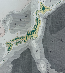
If the abstract notion of deep-sea worlds materialized as physical infrastructure with the completion of international telegraph cables in 1871, the fast-evolving visions of underwater landscapes opened the seabed to greater claims. The underwater geographies drafted around fragmentary sounding data from the Challenger and other international expeditions were largely speculative, and therefore easily appropriated for different claims over the ocean floor: if the “contours” of Japan emerged on the peninsula of Kamchatka, as one textbook claimed, then their continued meanders underwater turned the islands of the Pacific into geological outskirts of Japan’s archipelagic realm. Likewise, in the version of Iwakura Tomomi, the islands south of Japan were part of the mountain range of Izu province that ran off the slopes of Mount Fuji. The mountain peaks visible as islands were therefore naturally a part of greater Japan. In other words, the drafting of Japan’s deep sea geographies was closely tied to the archipelago’s strategical reorientation.